Focusing Exploration on High Grade Gold Silver Veins
Western Exploration Inc. (TSXV: WEX; OTCQX: WEXPF) (the "Company" or "Western Exploration") is pleased to announce the results of its surface exploration work program on the Gravel Creek resource area of the Aura Project.
This press release features multimedia. View the full release here: https://www.businesswire.com/news/home/20230306005310/en/
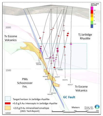
Figure 1. Cross section through Gravel Creek deposit, highlighting +5.0 g/t Au intercepts in legacy holes in the Miocene Jarbidge rhyolite overlying/adjacent to the Gravel Creek deposit area. Potential NE-trending structures with intercepts between the 1,500 and 1,750 meter elevations will be targeted with oriented core drilling in the upcoming field season. (Graphic: Business Wire)
Highlights from the work include:
- Rock geochemistry and detailed structural mapping completed in 2022 support the concept of NE-trending structures as a secondary ore control to the Gravel Creek system, which were noted in 2020 oriented core.
- An area with multiple high-grade Au-Ag vein intercepts of up to 40.05 g/t Au and 1,951 g/t Ag in the overlying felsic volcanic rocks will be targeted for drilling, focusing on NE trending structural zones with potential to expand resources.
- Au-Ag-As-Sb-Mo anomalies in soil and rock geochemistry occur up to 2.0 kilometers to the NE of the Gravel Creek resource, further extending the exploration potential.
Western Exploration CEO, Darcy Marud, said, "Western Exploration has long believed in the potential to greatly expand resources within the Wood Gulch/Gravel Creek mineralized system, and this data gives us additional confidence for drilling in the upcoming field season. The integration of structural alteration and geochemical data with the oriented core from hole WG450 has brought a greater understanding of the controls on the high-grade veins in the Jarbidge rhyolite overlying and peripheral to the Gravel Creek deposit. Oriented core is planned to verify structural trends and continuity of mineralization, with the ultimate goal of adding the known mineralization into the project resource base. The data also gives us further encouragement to continue to evaluate the Gravel Creek resource area for new areas of mineralization."
Multiple High Grade Gold and Silver Vein Drill Intercepts above and Peripheral to the Gravel Creek Deposit
Previous drilling, as reported in the Company's current technical report, titled "2021 Updated Resource Estimates and Technical Report For the Aura Gold-Silver Project, Elko County, Nevada" dated October 20, 2021 (with an effective date of October 14, 2021) (the "Technical Report"), has intersected multiple Au-Ag bearing vein intercepts in the Miocene Jarbidge volcanics overlying and lateral to the Gravel Creek deposit (see Tables 1 and 2), with grades up to 40.05 g/t Au and 1,951 g/t Ag. A cross section through the deposit shows intercepts of over 30.0 g/t AuEq in the Jarbidge rhyolite lie between the 1,500 and 1,750 meter elevation range, which corresponds to best grades in the main resource zone in the Frost Creek tuff (see Figure 1). None of these Jarbidge-hosted intercepts have been included in previous resource calculations, due to the uncertainty of orientation.
One core hole drilled in 2020 was angled SE to NW to test for the presence of NE trending vein zones within the Jarbidge rhyolite. Hole WG450 was drilled 190 meters NE of the Gravel Creek resource and intersected three high grade vein zones, carrying 1.52 meters at 4.07 g/t Au and 363 g/t Ag, 1.83 meters at 7.22 g/t Au and 334. 3 g/t Ag, and 0.3 meters at 37.1 g/t Au and 1,951 g/t Ag (see Table 2). The second intercept, as well as four smaller quartz-pyrite-marcasite vein zones, had strikes of N45-68E with dips from 65-90NW.
Table 1. Summary of historic +5.0 g/t AuEq intercepts in the Jarbidge rhyolite, sorted by elevation. The intercepts (+30.0 g/t AuEq) lie between the 1,500 and 1,750-meter elevations. The drill results are reported in the Technical Report. True widths are currently unknown but estimated to be between 25% and 75% of drill widths.
Hole |
Elevation (m) |
From (m) |
To (m) |
Drill Width (m) |
Au g/t |
Ag g/t |
AuEq g/t (70:1) |
WG448 |
2175 |
234.57 |
235.58 |
1.01 |
6.87 |
177.0 |
9.40 |
WG377 |
1941 |
239.27 |
242.32 |
3.05 |
6.19 |
69.3 |
7.18 |
WG376 |
1922 |
269.75 |
271.27 |
1.52 |
13.25 |
18.7 |
13.52 |
WG450 |
1910 |
226.47 |
227.99 |
1.52 |
4.07 |
363.0 |
9.26 |
WG450 |
1886 |
254.20 |
256.03 |
1.83 |
7.22 |
334.3 |
12.00 |
WG427 |
1840 |
376.43 |
377.95 |
1.52 |
8.39 |
79.1 |
9.52 |
WG422 |
1828 |
385.57 |
388.61 |
3.04 |
7.49 |
304.4 |
11.84 |
WG417 |
1758 |
440.44 |
443.48 |
3.04 |
40.05 |
1144.0 |
56.39 |
WG450 |
1746 |
409.93 |
410.23 |
0.30 |
37.10 |
1951.0 |
64.97 |
WG374 |
1733 |
466.34 |
467.87 |
1.53 |
15.40 |
15.7 |
15.62 |
WG379 |
1712 |
480.06 |
489.20 |
9.14 |
41.55 |
130.8 |
43.42 |
WG374 |
1710 |
487.68 |
495.30 |
7.62 |
25.60 |
75.2 |
26.67 |
WG434 |
1707 |
477.01 |
478.74 |
1.73 |
13.05 |
480.0 |
19.91 |
WG434 |
1692 |
490.73 |
493.78 |
3.05 |
12.02 |
549.0 |
19.86 |
WG377 |
1647 |
541.02 |
542.54 |
1.52 |
24.30 |
1655.0 |
47.94 |
WG377 |
1621 |
563.88 |
565.40 |
1.52 |
26.00 |
713.0 |
36.19 |
WG401 |
1620 |
562.36 |
563.88 |
1.52 |
12.65 |
384.0 |
18.14 |
WG434 |
1617 |
568.45 |
569.98 |
1.53 |
5.53 |
1.1 |
5.55 |
WG377 |
1608 |
576.07 |
577.60 |
1.53 |
11.25 |
385.0 |
16.75 |
WG401 |
1606 |
576.07 |
577.60 |
1.53 |
5.12 |
74.8 |
6.19 |
WG445 |
1602 |
612.95 |
615.39 |
2.44 |
35.60 |
28.6 |
36.01 |
WG434 |
1597 |
588.26 |
590.40 |
2.14 |
29.65 |
900.2 |
42.51 |
WG377 |
1584 |
603.50 |
608.80 |
5.30 |
23.36 |
799.2 |
34.78 |
WG401 |
1547 |
635.51 |
638.56 |
3.05 |
5.68 |
25.7 |
6.05 |
Table 2. Collar coordinates for Gravel Creek holes referenced in Table 1.
Hole |
East |
North |
Elev |
Azimuth |
Dip |
Depth (m) |
Type |
WG374 |
587,182 |
4,616,091 |
2,183 |
263.1 |
-66 |
646.2 |
RC |
WG376 |
587,239 |
4,616,231 |
2,193 |
253.2 |
-90 |
830.6 |
RC |
WG377 |
587,194 |
4,616,092 |
2,182 |
101.5 |
-89 |
780.3 |
RC |
WG379 |
587,179 |
4,616,191 |
2,196 |
220.3 |
-90 |
698.0 |
RC |
WG401 |
587,181 |
4,616,094 |
2,182 |
270.2 |
-85 |
968.4 |
RC/Core |
WG417 |
587,302 |
4,616,299 |
2,197 |
274.0 |
-81 |
898.3 |
RC/Core |
WG422 |
586,825 |
4,616,100 |
2,167 |
90.7 |
-58 |
623.6 |
RC/Core |
WG427 |
587,182 |
4,616,351 |
2,198 |
270.7 |
-71 |
893.7 |
Core |
WG434 |
587,351 |
4,616,160 |
2,175 |
237.3 |
-78 |
985.9 |
Core |
WG445 |
587,223 |
4,616,266 |
2,195 |
231.4 |
-73 |
821.9 |
Core |
WG448 |
587,303 |
4,616,130 |
2,176 |
241.7 |
-66 |
669.8 |
Core |
WG450 |
587,536 |
4,616,045 |
2,110 |
292.5 |
-60 |
691.9 |
Core |
UTM Coordinates NAD83, Zone 11 |
|||||||
Additional Geochemistry and Structural Mapping at Gravel Creek
Rock geochemistry and detailed structural mapping completed in 2022 on Discovery Hill above the Gravel Creek resource area provides additional evidence supporting the concept of NE-trending structures as a secondary ore control to the Gravel Creek system. Systematic mapping and sampling of veins and hydrothermal breccia dikes on Discovery Hill, approximately 400 meters vertically above the Gravel Creek deposit, has shown that mineralized samples show a strong preferred orientation of N50-85E/235-265SW, dipping over 80 degrees to the NW or SE (see Table 3 and Figure 2).
Table 3. Select 2022 Rock Geochemical Results from Gravel Creek Discovery Hill and NE Badger areas*. A complete list of assays is included in Appendix 1.
AREA |
Sample # |
Au ppm |
Ag ppm |
Ag/Au ratio |
As ppm |
Sb ppm |
Mo ppm |
Azimuth * |
Dip |
DISCOVERY HILL
|
AU22-172 |
0.87 |
23.8 |
27 |
904 |
34 |
6 |
50 |
90 |
AU22-136 |
0.80 |
31.3 |
39 |
452 |
43 |
4 |
50 |
80 |
|
AU22-144 |
0.52 |
48.2 |
93 |
334 |
87 |
7 |
50 |
80 |
|
AU22-169 |
0.70 |
22.1 |
32 |
630 |
85 |
14 |
55 |
75 |
|
AU22-140 |
0.50 |
28.8 |
57 |
358 |
92 |
6 |
60 |
90 |
|
AU22-146 |
0.67 |
41.7 |
63 |
625 |
156 |
8 |
65 |
90 |
|
AU22-177 |
0.68 |
15.6 |
23 |
753 |
50 |
5 |
75 |
90 |
|
AU22-170 |
0.98 |
92.2 |
94 |
781 |
186 |
160 |
85 |
80 |
|
AU22-135 |
1.12 |
59.1 |
53 |
370 |
71 |
5 |
155 |
80 |
|
AU22-141 |
0.55 |
34.4 |
63 |
532 |
81 |
8 |
235 |
80 |
|
AU22-178 |
0.59 |
15.7 |
27 |
592 |
49 |
5 |
250 |
75 |
|
AU22-182 |
0.54 |
22.3 |
41 |
792 |
45 |
5 |
255 |
80 |
|
AU22-162 |
0.53 |
24.5 |
47 |
217 |
33 |
11 |
265 |
80 |
|
AU22-159 |
0.66 |
21.7 |
33 |
456 |
92 |
12 |
270 |
85 |
|
AU22-174 |
0.60 |
19.4 |
32 |
636 |
59 |
17 |
320 |
75 |
|
AU22-155 |
0.57 |
17.9 |
31 |
443 |
80 |
226 |
325 |
40 |
|
AU22-143 |
0.60 |
37.6 |
63 |
547 |
111 |
7 |
335 |
90 |
|
AU22-142 |
0.59 |
42.7 |
72 |
446 |
147 |
8 |
350 |
70 |
|
* Samples > 0.5 ppm Au, sorted by Azimuth (full set of sample assays in Appendix 1) |
|||||||||
|
|||||||||
AREA |
Sample # |
Au ppm |
Ag ppm |
Ag/Au ratio |
As ppm |
Sb ppm |
Mo ppm |
|
|
N. BADGER
|
781634 |
0.23 |
36.4 |
160 |
416 |
34 |
351 |
|
|
781636 |
0.22 |
8.4 |
39 |
627 |
44 |
4 |
|
|
|
781638 |
1.62 |
19.4 |
12 |
1355 |
84 |
26 |
|
|
|
781640 |
0.04 |
3.4 |
97 |
198 |
7 |
5 |
|
|
|
781645 |
0.53 |
21.8 |
41 |
902 |
49 |
56 |
|
|
|
781647 |
0.72 |
42.3 |
58 |
672 |
48 |
224 |
|
|
|
781649 |
1.21 |
36.2 |
30 |
1130 |
73 |
46 |
|
|
|
781651 |
0.09 |
3.0 |
35 |
150 |
6 |
5 |
|
|
|
All analyses by ALS Chemex: gold by AuAA23 and other elements by ME-ICP41 |
|||||||||
Surface Exploration has Identified Additional Potential Drill Targets
The 2020 oriented core data, in combination with 2022 surface data, has been modeled in Vulcan and Leapfrog 3D software to define tentative high angle, NE-trending structural corridors. These will be tested with angle holes drilled NW to SW, targeting the Jarbidge rhyolite at the 1,500 to 1,750 meter elevation (see Figure 1). If successful, additional drill results could allow Western Exploration to expand its existing mineral resource within the Jarbidge rhyolite at Gravel Creek.
Outcrop and subcrop samples 1.0 kilometer NE of Gravel Creek support exploration potential
Of broader exploration significance, the 2022 data gives additional support for the exploration potential associated with strong, multi-element soil anomaly, which extends 2.0 kilometers to the NE of the Gravel Creek area, parallel to a density anomaly which extends from Wood Gulch through Gravel Creek and to the NE (see Figure 3). Rock outcrop/sub crop sampling of a small area of alteration and veining 1.0 kilometer NE of the Gravel Creek resource in the NE Badger area returned Au-Ag-As-Sb-Mo values comparable to the levels seen directly over the Gravel Creek deposit. The 1.61 g/t Au sample from the NE Badger anomaly is the highest-grade surface gold value collected to-date in the Jarbidge rhyolite and the highly anomalous Mo (up to 256 ppm) is suggestive of a upflow zone within the hydrothermal system (see Table 1 and Figure 4).
About the Aura Project
As outlined in the Technical Report (which was prepared in accordance with the requirements of National Instrument 43-101 – Standards of Disclosure for Mineral Projects ("NI 43-101")), the Aura Project has well established infrastructure including year-round accessibility by highway and county-maintained road and nearby access to water and electricity (see Figure 5). Western Exploration has exploration, development, and mining rights on 930 hectares of privately owned fee lands through a mineral lease agreement with a local landowner and may purchase those fee lands at any time for the development of Doby George.
The 6,000-hectare Aura Project has identified mineral resources in three different deposits (Doby George, Gravel Creek and Wood Gulch), as supported by the Technical Report (see Table 4 below).
Table 4. Updated mineral resource estimates for the Aura Project as contained in the 2021 Technical Report
MINERAL RESOURCE ESTIMATE(1) |
||||||||||||||
|
Indicated |
Inferred |
||||||||||||
Tonnes |
Au (g/t) |
Au
|
Ag (g/t) |
Ag
|
AuEq (g/t) |
AuEq (oz.) |
Tonnes |
Au (g/t) |
Au
|
Ag (g/t) |
Ag
|
AuEq (g/t) |
AuEq (oz.) |
|
Doby George(2) |
12,922,000 |
0.98 |
407,000 |
- |
- |
0.98 |
407,000 |
4,999,000 |
0.73 |
118,000 |
- |
- |
0.73 |
118,000 |
Wood Gulch(3) |
- |
- |
- |
- |
- |
- |
- |
4,359,000 |
0.66 |
93,000 |
5.80 |
808,000 |
0.74 |
104,543 |
Gravel Creek(4) |
1,315,000 |
4.73 |
200,000 |
75.0 |
3,169,000 |
5.81 |
245,271 |
2,744,000 |
4.16 |
367,000 |
60.20 |
5,307,000 |
5.02 |
442,814 |
TOTAL |
14,237,000 |
1.33 |
607,000 |
75.0 |
3,169,000 |
1.43 |
652,271 |
12,102,000 |
1.48 |
578,000 |
15.74 |
6,115,000 |
1.71 |
665,357 |
Notes:
(1) Au equivalent oz assumes US$1,800 per oz Au and 70:1 ratio of Ag:Au.
(2) Pit constrained 0.2 g/t AuEq cutoff for oxide, 0.4 g/t Au cutoff for mixed and 1.4 g/t Au cutoff for unoxidized.
(3) Pit constrained 0.2 g/t AuEq cutoff.
(4) 3.0 g/t Au cutoff.
See "Cautionary Statements Regarding Estimates of Mineral Resources" below.
About Western Exploration
Born from a 25-year history of advancing exploration projects in Nevada as a private company, today Western Exploration is composed of an experienced team of precious metals experts that aims to lead Western Exploration to becoming a premiere gold and silver development company in North America. The Company's principal asset is the 100% owned Aura gold-silver project, located approximately 120 kilometers/75 miles north of the city of Elko, Nevada, and includes three unique gold and silver deposits: Doby George, Gravel Creek, and Wood Gulch. Additional information regarding Western Exploration and the Aura Project can be found on the Company's website and on SEDAR (www.sedar.com) under the Company's issuer profile.
Qualified Person Approval
The scientific and technical content in this news release has been reviewed and approved by Mark Hawksworth, General Manager of the Aura Project, and a "qualified person" within the meaning of NI 43-101.
Quality Assurance / Quality Control
Legacy drill intercepts are reported at 5.0 g/t Au cutoff, with assays uncut. Exploration program design, Quality Assurance/Quality Control ("QA/QC") and the interpretation of results is performed by qualified persons employing a QA/QC program consistent with NI 43-101 and industry best practices. Standards and blanks are inserted approximately every 20th sample into the sample stream for QA/QC purposes by the Company as well as the lab. Surface geochemical samples are generally only at anomalous levels and are never used in resource calculations. However, professionally prepared standards were inserted into the sample sequence submitted to ALS CHEMEX to maintain control on assays for comparison purposes. Please see below under the heading "Cautionary Note Regarding Forward-Looking Information" for further details regarding the risks facing Western Exploration.
For additional information on the Aura Project, please see the Technical Report, which has been prepared in accordance with the requirements of NI 43-101, a copy of which is available on SEDAR (www.sedar.com) under Western Exploration's issuer profile and on Western Exploration's corporate website (www.westernexploration.com).
Cautionary Statements Regarding Estimates of Mineral Resources
This news release uses the terms measured, indicated and inferred mineral resources as a relative measure of the level of confidence in the resource estimate. Readers are cautioned that mineral resources are not mineral reserves and that the economic viability of resources that are not mineral reserves has not been demonstrated. The mineral resource estimate disclosed in this news release may be materially affected by geology, environmental, permitting, legal, title, socio-political, marketing or other relevant issues. The mineral resource estimate is classified in accordance with the Canadian Institute of Mining, Metallurgy and Petroleum's "CIM Definition Standards on Mineral Resources and Mineral Reserves" (CIM) incorporated by reference into NI 43-101. Under NI 43-101, estimates of inferred mineral resources may not form the basis of feasibility or pre-feasibility studies or economic studies except for preliminary economic assessments. Readers are cautioned not to assume that further work on the stated resources will lead to mineral reserves that can be mined economically.
Inferred mineral resources have a great amount of uncertainty as to their existence and as to whether they can be mined legally or economically. On October 31, 2018, the SEC adopted new mining disclosure rules ("S-K 1300") that are more closely aligned with current industry and global regulatory practices and standards, including NI 43-101, although there are some differences in the two standards. Accordingly, information concerning mineral deposits contain in this release may not be comparable with information made public by U.S. companies that report in accordance with S-K 1300.
Cautionary Note Regarding Forward-Looking Information
This news release may contain "forward-looking information" and "forward-looking statements" within the meaning of the applicable Canadian and United States securities legislation (collectively, "forward-looking statements"). These forward-looking statements, by their nature, require the Company to make certain assumptions and involve known and unknown risks and uncertainties that could cause actual results to differ materially from those expressed or implied in such forward-looking statements. Any statement that involves predictions, expectations, interpretations, beliefs, plans, projections, objectives, assumptions, future events or performance (often, but not always, using phrases such as "expects", or "does not expect", "is expected", "interpreted", "management's view", "anticipates" or "does not anticipate", "plans", "budget", "scheduled", "forecasts", "estimates", "potential", "feasibility", "believes" or "intends" or variations of such words and phrases or stating that certain actions, events or results "may" or "could", "would", "might" or "will" be taken to occur or be achieved) are not statements of historical fact and may be forward-looking information and are intended to identify forward-looking information. This news release contains the forward-looking information pertaining to, among other things: the focus and results of the surface exploration program; the accuracy of results from prior exploration activities conducted at the Aura Project; the key assumptions, parameters and methods used to estimate the mineral resource estimate disclosed in this news release; the prospects, if any, of the Doby George, Wood Gulch and Gravel Creek mineral deposits; future drilling at the Aura Project; the significance of historic exploration activities and results; and the ability to expand the existing mineral resources at the Aura Project. Such factors include, among others, risks relating to the ability of exploration activities (including drill results) to accurately predict mineralization; errors in management's geological modelling; the ability of Western Exploration to complete further exploration activities, including drilling; property and royalty interests in respect of the Aura Project; the ability of the Company to obtain required approvals; the results of exploration activities; risks relating to mining activities; the global economic climate; metal prices; dilution; environmental risks; and community and non-governmental actions. Although the forward-looking information contained in this news release is based upon what management believes, or believed at the time, to be reasonable assumptions, Western Exploration cannot assure shareholders and prospective purchasers of securities of the Company that actual results will be consistent with such forward-looking information, as there may be other factors that cause results not to be as anticipated, estimated or intended, and neither Western Exploration nor any other person assumes responsibility for the accuracy and completeness of any such forward-looking information. Western Exploration does not undertake, and assumes no obligation, to update or revise any such forward-looking statements or forward-looking information contained herein to reflect new events or circumstances, except as may be required by law.
For additional information with respect to these and other factors and assumptions underlying the forward‐looking statements and forward-looking information made in this news release concerning Western Exploration, see the management information circular dated November 12, 2021, available electronically under Western Exploration's issuer profile on SEDAR (www.sedar.com). The forward-looking statements set forth herein concerning Western Exploration reflect management's expectations as at the date of this news release and are subject to change after such date. Western Exploration disclaims any intention or obligation to update or revise any forward-looking statements, whether as a result of new information, future events or otherwise, other than as required by law.
Neither the TSX Venture Exchange nor its Regulation Services Provider (as that term is defined in the policies of the TSX Venture Exchange) accepts responsibility for the adequacy or accuracy of this news release. No stock exchange, securities commission or other regulatory authority has approved or disapproved the information contained herein.
Appendix 1: Complete list of 2023 surface rock samples in Discovery Hill and N. Badger areas.
Area |
Sample # |
Easting (m)* |
Northing (m) |
Elevation (m) |
Au ppm |
Ag ppm |
As ppm |
Mo ppm |
Sb ppm |
Azimuth |
Dip |
Discovery Hill |
AU22-134a |
586,945 |
4,615,927 |
2137 |
0.43 |
26.0 |
262 |
8 |
39 |
350 |
90 |
|
AU22-135 |
586,952 |
4,615,930 |
2138 |
1.12 |
59.1 |
370 |
5 |
71 |
155 |
80 |
|
AU22-136 |
586,969 |
4,615,918 |
2141 |
0.80 |
31.3 |
452 |
4 |
43 |
50 |
80 |
|
AU22-137 |
587,001 |
4,615,908 |
2145 |
0.31 |
14.2 |
1045 |
6 |
50 |
230 |
65 |
|
AU22-138 |
587,005 |
4,615,908 |
2148 |
0.28 |
12.4 |
416 |
5 |
29 |
52 |
90 |
|
AU22-139 |
587,008 |
4,615,907 |
2148 |
0.49 |
24.6 |
745 |
6 |
46 |
215 |
70 |
|
AU22-140 |
587,018 |
4,615,907 |
2153 |
0.50 |
28.8 |
358 |
6 |
92 |
60 |
90 |
|
AU22-141 |
587,021 |
4,615,906 |
2151 |
0.55 |
34.4 |
532 |
8 |
81 |
235 |
80 |
|
AU22-142 |
587,023 |
4,615,906 |
2151 |
0.59 |
42.7 |
446 |
8 |
147 |
350 |
70 |
|
AU22-143 |
587,026 |
4,615,906 |
2153 |
0.60 |
37.6 |
547 |
7 |
111 |
335 |
90 |
|
AU22-144 |
587,029 |
4,615,906 |
2153 |
0.52 |
48.2 |
334 |
7 |
87 |
50 |
80 |
|
AU22-145 |
587,032 |
4,615,906 |
2153 |
0.01 |
0.7 |
14 |
3 |
4 |
25 |
70 |
|
AU22-146 |
587,037 |
4,615,906 |
2155 |
0.67 |
41.7 |
625 |
8 |
156 |
65 |
90 |
|
AU22-147 |
587,040 |
4,615,906 |
2155 |
0.40 |
15.4 |
534 |
8 |
48 |
325 |
70 |
|
AU22-148 |
587,041 |
4,615,906 |
2155 |
0.23 |
14.1 |
329 |
8 |
34 |
225 |
60 |
|
AU22-149 |
587,043 |
4,615,906 |
2153 |
0.01 |
2.6 |
158 |
7 |
9 |
200 |
16 |
|
AU22-150 |
587,044 |
4,615,906 |
2153 |
0.26 |
14.4 |
373 |
6 |
37 |
35 |
55 |
|
AU22-151 |
587,048 |
4,615,906 |
2150 |
0.19 |
10.2 |
379 |
6 |
34 |
55 |
75 |
|
AU22-152 |
587,052 |
4,615,906 |
2149 |
0.12 |
11.0 |
196 |
8 |
29 |
38 |
84 |
|
AU22-153 |
587,053 |
4,615,906 |
2148 |
0.13 |
13.1 |
240 |
3 |
13 |
42 |
74 |
|
AU22-154 |
587,071 |
4,615,908 |
2148 |
0.01 |
0.9 |
26 |
7 |
3 |
330 |
70 |
|
AU22-155 |
587,074 |
4,615,908 |
2145 |
0.57 |
17.9 |
443 |
226 |
80 |
325 |
40 |
|
AU22-156 |
587,079 |
4,615,910 |
2149 |
0.02 |
0.9 |
83 |
4 |
12 |
345 |
75 |
|
AU22-157 |
587,088 |
4,615,914 |
2149 |
0.32 |
11.4 |
591 |
9 |
33 |
305 |
60 |
|
AU22-158 |
587,095 |
4,615,917 |
2149 |
0.03 |
1.5 |
80 |
5 |
8 |
320 |
55 |
|
AU22-159 |
587,096 |
4,615,918 |
2149 |
0.66 |
21.7 |
456 |
12 |
92 |
270 |
85 |
|
AU22-160 |
587,096 |
4,615,919 |
2150 |
0.10 |
1.2 |
209 |
8 |
15 |
5 |
80 |
|
AU22-161 |
587,098 |
4,615,921 |
2149 |
0.35 |
14.6 |
501 |
15 |
34 |
280 |
73 |
|
AU22-162 |
587,102 |
4,615,925 |
2147 |
0.53 |
24.5 |
217 |
11 |
33 |
265 |
80 |
|
AU22-163 |
587,111 |
4,615,934 |
2148 |
0.27 |
10.3 |
309 |
13 |
35 |
260 |
80 |
|
AU22-164 |
587,134 |
4,615,950 |
2149 |
0.19 |
7.6 |
307 |
8 |
30 |
60 |
90 |
|
AU22-165 |
587,148 |
4,615,953 |
2147 |
0.09 |
4.7 |
497 |
48 |
18 |
95 |
90 |
|
AU22-166 |
587,171 |
4,615,964 |
2152 |
0.34 |
6.2 |
333 |
3 |
33 |
325 |
65 |
|
AU22-167 |
587,071 |
4,615,842 |
2132 |
0.23 |
3.4 |
560 |
3 |
25 |
35 |
65 |
|
AU22-168 |
587,051 |
4,615,852 |
2130 |
0.38 |
7.2 |
632 |
6 |
30 |
55 |
85 |
|
AU22-169 |
586,988 |
4,615,868 |
2132 |
0.70 |
22.1 |
630 |
14 |
85 |
55 |
75 |
|
AU22-170 |
586,956 |
4,615,873 |
2122 |
0.98 |
92.2 |
781 |
160 |
186 |
85 |
80 |
|
AU22-171 |
586,961 |
4,615,865 |
2120 |
0.10 |
6.2 |
471 |
10 |
18 |
175 |
85 |
|
AU22-172 |
586,974 |
4,615,851 |
2119 |
0.87 |
23.8 |
904 |
6 |
34 |
50 |
90 |
|
AU22-173 |
586,999 |
4,615,837 |
2117 |
0.05 |
1.4 |
181 |
3 |
20 |
335 |
45 |
|
AU22-174 |
587,199 |
4,615,876 |
2109 |
0.60 |
19.4 |
636 |
17 |
59 |
320 |
75 |
|
AU22-175 |
587,004 |
4,615,942 |
2168 |
0.01 |
<0.2 |
25 |
1 |
<2 |
350 |
73 |
|
AU22-176 |
587,002 |
4,615,945 |
2165 |
0.01 |
<0.2 |
16 |
3 |
2 |
10 |
75 |
|
AU22-177 |
586,999 |
4,615,946 |
2163 |
0.68 |
15.6 |
753 |
5 |
50 |
75 |
90 |
|
AU22-178 |
586,993 |
4,615,950 |
2163 |
0.59 |
15.7 |
592 |
5 |
49 |
250 |
75 |
|
AU22-179 |
587,159 |
4,616,009 |
2173 |
0.25 |
10.1 |
982 |
21 |
36 |
280 |
55 |
|
AU22-180 |
587,152 |
4,616,003 |
2173 |
0.07 |
4.1 |
371 |
7 |
12 |
240 |
55 |
|
AU22-181 |
587,017 |
4,615,958 |
2172 |
0.21 |
17.3 |
386 |
5 |
22 |
350 |
65 |
|
AU22-182 |
587,015 |
4,615,960 |
2173 |
0.54 |
22.3 |
792 |
5 |
45 |
255 |
80 |
|
AU22-183 |
586,993 |
4,615,975 |
2173 |
0.01 |
1.0 |
126 |
6 |
14 |
60 |
80 |
|
AU22-184 |
586,969 |
4,616,126 |
2201 |
0.07 |
32.2 |
283 |
6 |
45 |
255 |
25 |
|
AU22-185 |
586,969 |
4,616,110 |
2200 |
0.38 |
33.0 |
436 |
6 |
100 |
35 |
90 |
|
AU22-186 |
586,979 |
4,616,100 |
2204 |
0.30 |
16.2 |
318 |
7 |
38 |
55 |
90 |
|
AU22-187 |
586,981 |
4,616,097 |
2201 |
0.33 |
9.8 |
575 |
6 |
46 |
60 |
90 |
|
AU22-188 |
586,994 |
4,616,084 |
2204 |
0.01 |
0.6 |
105 |
6 |
9 |
10 |
90 |
|
AU22-189 |
586,997 |
4,616,079 |
2204 |
0.25 |
5.4 |
473 |
6 |
21 |
180 |
80 |
|
AU22-190 |
587,026 |
4,616,040 |
2197 |
0.02 |
0.6 |
82 |
3 |
8 |
65 |
85 |
|
AU22-191 |
587,055 |
4,616,027 |
2195 |
0.02 |
0.9 |
101 |
4 |
6 |
20 |
85 |
|
AU22-192 |
587,068 |
4,616,022 |
2194 |
0.04 |
1.0 |
229 |
3 |
9 |
10 |
70 |
|
AU22-193 |
587,069 |
4,616,022 |
2194 |
0.01 |
0.3 |
58 |
4 |
5 |
255 |
85 |
|
AU22-194 |
586,993 |
4,616,055 |
2199 |
0.02 |
0.8 |
134 |
13 |
5 |
350 |
73 |
|
AU22-195 |
586,980 |
4,616,061 |
2198 |
0.03 |
3.1 |
86 |
13 |
17 |
40 |
90 |
N. Badger |
781634 |
587,872 |
4,616,714 |
- |
0.23 |
36.4 |
416 |
351 |
34 |
|
|
|
781636 |
587,778 |
4,616,689 |
- |
0.22 |
8.4 |
627 |
4 |
44 |
|
|
|
781638 |
587,872 |
4,616,714 |
- |
1.62 |
19.4 |
1355 |
26 |
84 |
|
|
|
781640 |
587,784 |
4,616,685 |
- |
0.04 |
3.4 |
198 |
5 |
7 |
|
|
|
781645 |
587,874 |
4,616,715 |
- |
0.53 |
21.8 |
902 |
56 |
49 |
|
|
|
781647 |
587,866 |
4,617,714 |
- |
0.72 |
42.3 |
672 |
224 |
48 |
|
|
|
781649 |
587,871 |
4,616,713 |
- |
1.21 |
36.2 |
1130 |
46 |
73 |
|
|
|
781651 |
587,789 |
4,616,701 |
- |
0.09 |
3.0 |
150 |
5 |
6 |
|
|
All analyses by ALS Chemex: gold by AuAA23 and other elements by ME-ICP41 |
|||||||||||
* UTM Coordinates: NAD 83, Zone11 |
|||||||||||
View source version on businesswire.com: https://www.businesswire.com/news/home/20230306005310/en/
Contacts
For more information please contact:
Darcy Marud
Chief Executive Officer
Telephone: (775) 329-8119
Email: dmarud@westernexploration.com
Nichole Cowles
Investor Relations
Telephone: (775) 240-4172
Email: nicholecowles@westernexploration.com